Beinn Dubh Horseshoe

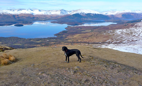
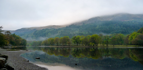
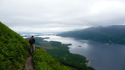
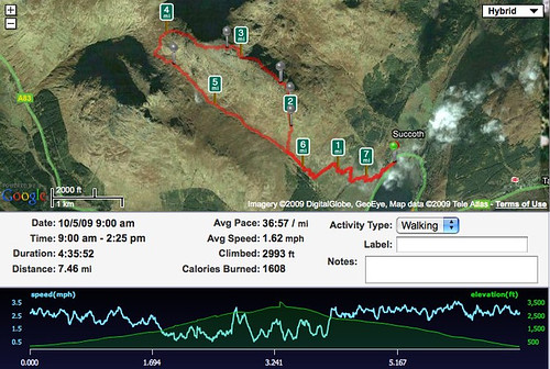
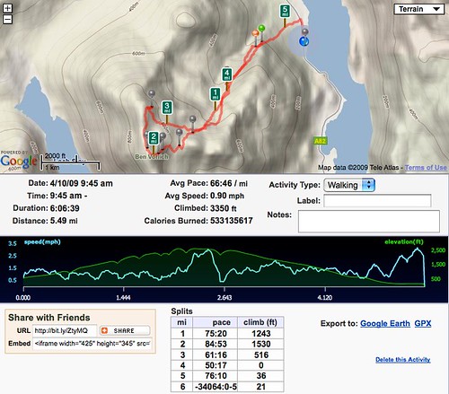
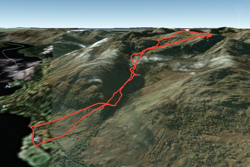
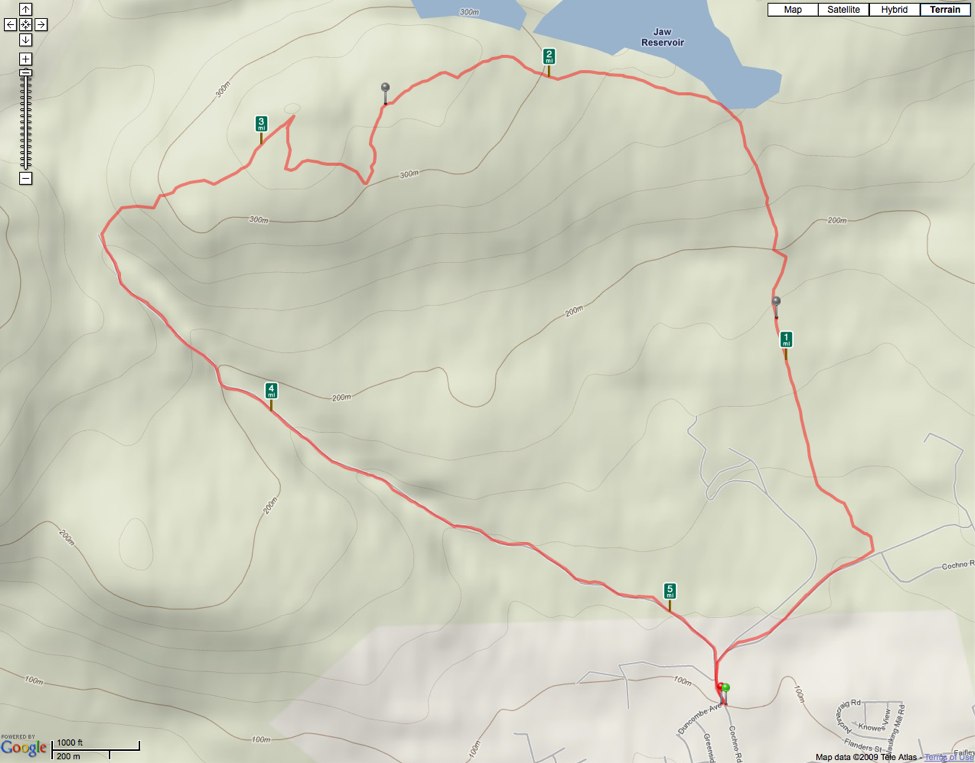
My latest walk was in glorious sunshine. We decided against a munro in case the summit was still snow clad, instead walking the Beinn Dubh Horseshoe. This is a just over seven mile route that starts from the small village of Luss on the edge of Loch Lomond.

Loch Lomond

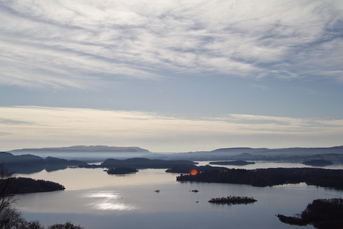
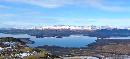
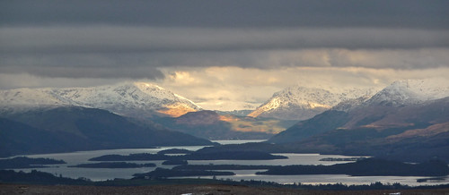
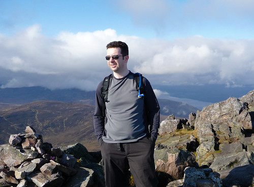
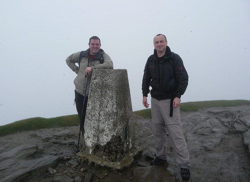
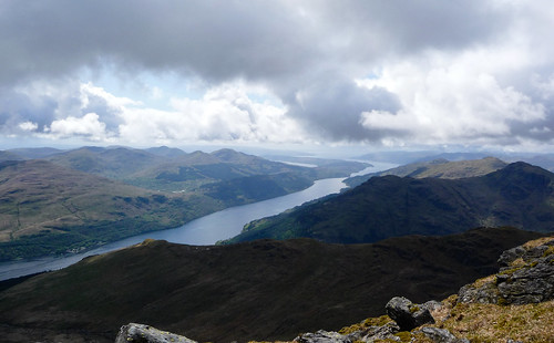
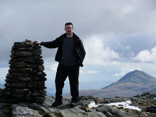
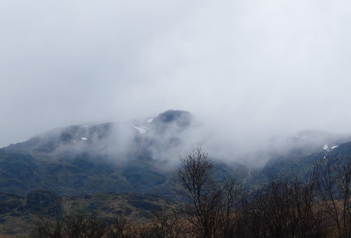
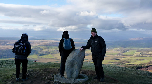
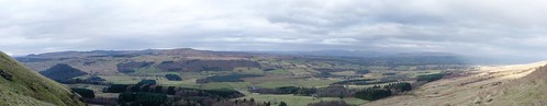
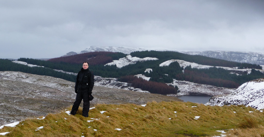
We walked over the wooden bridge that crosses the A82 and were soon on the assent up Beinn Dubh. Although there was a chill in the air the fleeces were dispensed with pretty quickly as there was warmth in the sun. It was also a pretty steep and constant climb to the Beinn Dubh summit. The views over Loch Lomond were stunning and from the summit there were great views of Ben Lomond and down Loch Lomond to distant hills in the North.

Beinn Dubh Summit

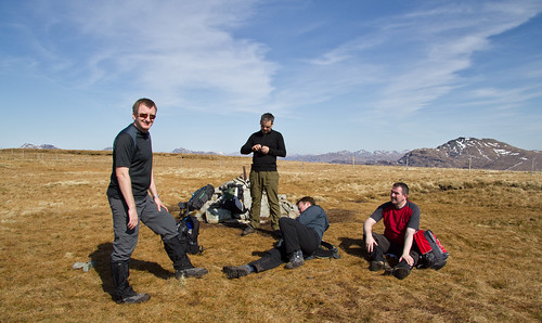
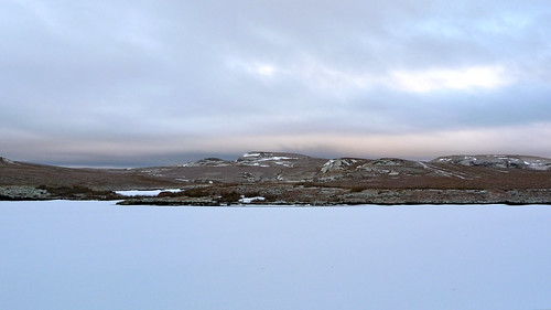
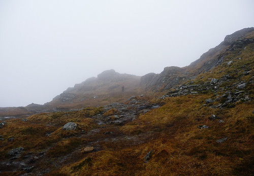
After a quick lunch we followed the path and fence into more boggier ground. This took us around the horseshoe and then down towards Luss again, Loch Lomond swinging into sight. You take a small rough road back to Luss which isn’t always downward but before long your crossing the wooden bridge and your in Luss car park again. A wword of warning – we set of early and the car park was empty but by mid afternoon it was swarming with visitors so get there early to an easy parking space.

Beinn Dubh Horseshoe Runkeeper

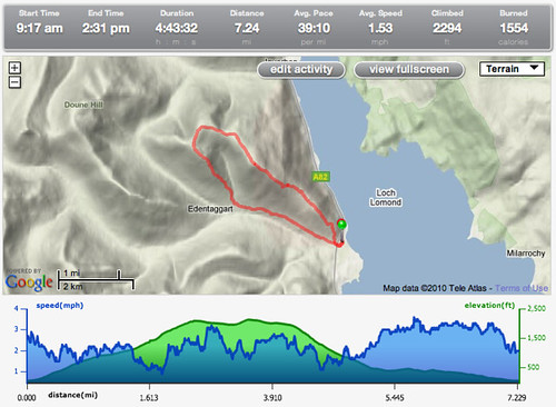
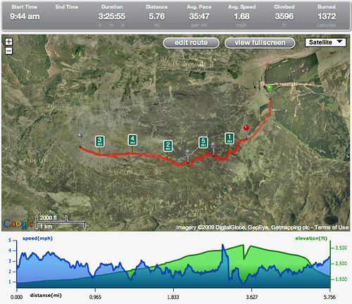
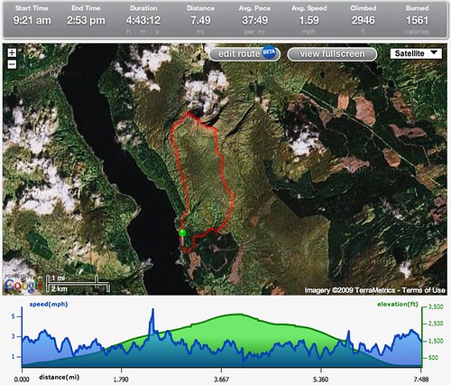
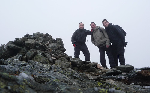
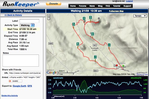
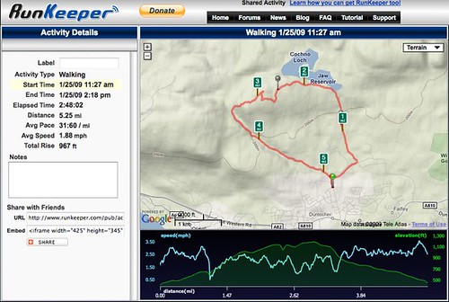
Looking at the Runkeeper timings indicate a four and a half hour walk but I never bothered stopping Runkeeper while we we stopped for breaks so it’s probably more like three and a half hours. Beinn Dubh horseshoe is a rewarding walk with great views all round and is strenuous enough to consider instead of a munro if the weather is against you. The full photo set can be found on Flickr. This was my first walk with the 550D. I was pleased with the photo’s although would have liked a bit more time to experiment. I took just the camera and one lens, leaving tripod and other bits and pieces. It was certainly more heavy and cumbersome compared to the point and shoot but the weather meant I had less walking gear to carry. The winter might not be so easy – I’ll certainly need a bigger back pack.

Conic Hill

The weather recently has been pretty good. Clear sky’s, crisp at night but getting slightly warmer during the day…time for a walk methinks. We considered a munro last weekend but blizzards at that height and pretty bad windchill predictions put us of. We considered a munro for today but there’s still a lot of snow on the hills so we settled for something local that’s easy to climb but promised good views if the clear skies held – Conic Hill.

Loch Lomond and Arracher Alps

Conic Hill is easily accessed from Balmaha car park. It only takes just over an hour to climb but as you can see from the photo’s here and at Flickr you can get some great views if the weather is clear. What was still a surprise was the amount of snow at this low level. We were up to out knee’s and sometimes more on the ascent and there was some ice to watch out for as well. Thankfully I’d picked up a pair of gaitors so my feet and legs kept dry. After returning to the car park we bumped into a work colleague who’d got up at 04:30 to get to Ben Lomond summit for sunrise. He said crampons and pick axe were a must for the conditions up there so we had made the right choice. For next winter it looks like they’ll be essential purchases.

Milly

Star of the day was Milly who seemed to have no problem with the climb or the conditions, even cooling off at the end with a wee swim in Loch Lomond. I say cooling off but she was shivering after a few minutes in the water – bless. So that was Conic Hill, a cracking walk to dust off the cobwebs or when the weather elsewhere prevents a more ambitious climb.

Winter Walking

The weather has been pretty cold and snowy recently but I’ve tried to not let it get in the way of getting out and about. Yes – it’s another one of those self righteous “I’ve been out walking again while you’ve been sat on your ass” posts.

A couple of weeks ago there was a fresh snowfall in Glasgow so I walked down to Kelvingrove Park to take some winter pic’s before the thaw kicked in. I wasn’t the only one with that idea as the park had loads of people in it, mostly taking pictures. The one’s I’m most pleased with? First up is this robin. I was pre-occupied with the ducks struggling against the flow in the Kelvin, a far cry from their more sedate duck pond which was frozen over. I then turned round and the robin was 4 foot away on the handrail of the bridge. Very lucky.

Robin

I then walked up uni avenue just as the sun started to break through. Got some lovely snaps of the Glasgow skyline in winter which will always remind me of days in the tenement. Views all over the south side with many a winters day looking like this.

Glasgow Winter Skyline

Today was the first hill walk of the year, a nice stroll in the Kilpatricks up Duncolm. I expected the snow and ice to be clear but there was still some snow and ice even at this lower level. Loch Humphrey was still frozen over!

Loch Humphrey

Again we were very lucky with the weather as it was mostly dry and from our lofty perch we could see the rain over Glasgow. It was also clearer further north and we could see many of the Perthshire hills and had a great view of Loch Lomond later in the morning.

Loch Lomond

I must admit, I still love the walks. Fresh air, escape for a few hours and a chance to clear the head. Scenery is usually amazing too. Next up in a few weeks (leg permitting!) is a 13 miles stretch of the West Highland Way. Can’t wait.

Schiehallion

After getting back in the swing with a walk up Tinto Hill it was time to tackle another munro. We had planned to do Schiehallion back in July but illness, holidays and finding a suitable weekend meant it never happened. So last Saturday we got up early and headed up to Perthshire. It was a two and a bit hour drive but empty country roads were fantastic. We were also pretty lucky with the weather and the day was dry with some clear spells. One very lucky find was Loch Lubnaig just to the north of Callandar.

Loch Lubnaig

Mirror like surface and some great photo’s. I don’t often think about a DSLR but this was one of those times that I knew a better camera would have been very handy. Onwards to Schiehallion which is 3547ft/1083m high and thanks to a well maintained car park and excellent path is fairly popular. As we climbed up the sun started coming out and it was getting pretty warm. The climb up is fairly steep but as I mentioned previously it’s helped by a great path. However the path doesn’t take you to the summit. You think your at the top but you’ve got around another mile of rocks and boulders to navigate before you get to the cairn. This was the trickiest bit of the walk and I can only imagine it’s fairly treacherous on a wet day. However it only took a couple of hours to get to the summit from the car park.

Me at Schiehallion Summit

Not long after these photo’s were taken the cloud rolled in and it got very cold -fleece and gloves required while we ate lunch and got going again. We were now on the north side of the hill and it was very slippy – I managed to cut my shin in four places as it slipped down a rock and you had to tread carefully to avoid a sprained ankle. We could have taken the old path back down but it had badly eroded the hill hence the newly constructed oath so we were respectful and retraced our steps back to the car park.

Schiehallion Runkeeper

This was a great walk and one that anyone could do as long as you’ve got the right footwear for the rocks on top and also remember that at this time of year it can be very cold and windy at the top of a munro compared to conditions on the ground. A full set of photo’s can be found on Flickr.

Ben Lomond

My latest walk was last weekend and was up probably the most popular Munro in Scotland – Ben Lomond. With it’s proximity to Glasgow and a path all the way to the top it’s easy to see why so many people climb it. Unfortunately the weather last Sunday meant that the view’s all the way up, including at the top, were very poor.

Jim and Danny

The photo above show’s what a grey driech day it was. Ugghhh. Worse the little blacks dot’s you can see in the photo’s. Midges. The little bastards loved me and I ended up with around 100 midge bites. I’ve spent the last week trying not to scratch them as they are itchy as hell. I’ve been told to eat plenty of garlic before my next walk as that seemingly act’s as a deterrent. Time will tell although I’d appreciate any advice if someone know’s better!

The other issue with Lomond was just how busy the route was. We took the tourist path to the top and there were just too many scallies for our liking. You never felt you were in the great outdoors. After escaping the summit and grabbing some lunch away from midge hell we took the trickier route back down and we were rewarded with a far more interesting, trickier route which was quieter too – woo hoo. Even better, the clouds lifted slightly meaning we did get a couple of nicer pic’s.

Danny and Loch Lomond

I loved the walk down and next time I do Lomond I’ll be taking this route up and down as it really made the day for me. One other lesson was I need to drink more – I ended up with a migraine after the walk and feeling pretty dehydrated – not smart at all and something I’ll need to be careful with next time. Lot’s more liquid before and during the walk are required especially in the hotter weather.

Ben Lomond Runkeeper

This was the first walk with the iPhone 3GS and Runkeeper. Never let me down once and the battery life, I think, is better or the 3GS than the 3G but not by much. The full Flickr set is available here. Looking forward to the next walk already – here’s hoping for better weather.

Beinn Narnain

After the last walk on Ben Vorlich yesterdays stroll up Beinn Narnain was in complete contrast. Narnain is also (just) a munro and is situated on the banks of Loch Long, just across from Arrochar. The biggest difference was the weather – it was an almost perfect day! The next biggest difference – we followed the path!

View at Lunchtime

Heading out from the car park it was a fairly straightforward path towards the Cobbler on the left and Narnain to the right. This was our only rain of the day on the hill and it quickly passed. We left the path a bit early (or missed an earlier path) so we had a bit of a slog for about 40 mins. After that though it was path for most of the way. There was also quite a bit more scrambling than before and it was a little slippy underfoot at some points. However once we got to the top the views were stunning. Picture above is where I had lunch and here’s me at the trig point on top of Narnain.

Me on Narnaim

With lot’s of breaks it took just under three hours to get to the top which was pretty good going. The route down was pretty good with a clear path and some scrambling over rocks but nothing too taxing. One option was to do The Cobbler as well but we decided to keep that for another day. Something I should have done was put on some sun cream. I burn easily and with the better weather I’ve got a red nose and neck today. Nothing too bad but easily preventable.

Beinn Narnaim Runkeeper

I again used RunKeeper to track the route and this time it didn’t work flawlessly. The iPhone/RunKeeper lost GPS signal or at least couldn’t get an accurate signal and it thought we had walked 16 miles near the top of Narnain. When I loaded the total walk up to the RunKeeper site it was showing we had walked over 20 miles. Damn. However you can now edit the route by moving waypoints. Five minutes later and with the route corrected RunKeeper updated the walk calculating the correct distance. Fantastic. This was also the first time with the newly updated RunKeeper which now lets you switch the screen off while using it. The battery life is now much improved. By the time I go to the top of Ben Narnain I still had 1/3 battery life left. I plugged in my battery pack and it only took a quarter of the charge to fully charge the iPhone. I now expect to be able to track for at least 10 hours which is really good and much longer than I initially expected.

So that’s my second Munro done. Full Flickr set is available here. I wonder where we’ll end up in June?

Ben Vorlich

Took advantage of a holiday on Good Friday to tackle my third walk. We weren’t sure whether to head further up North but we decided on something closer to home, and something a bit bigger. So we headed to the top of Loch Lomond to tackle Ben Vorlich. This would be my biggest walk so far and also my first munro – Ben Vorlich is 943m, so just over the magic 3000ft mark. It also turned out to be far more difficult than expected.

We started around 9AM and according to the guide books it should have taken around five hours. We took just over seven. Partly this was down to taking plenty stops as it was hard going. Partly it was down to never finding a path up or down Ben Vorlich which made it far more tiring.

Ben Vorlich

The weather started off a bit wet and we couldn’t see the summit due to the low cloud. We could still see snow though at the top. We hoped the low cloud would lift but unfortunately it didn’t so views were limited which is a shame when you look at some of the views we could have got. The ground was very heavy – boggy, muddy and it made most of the trip up quite a slog. Thankfully the rain lifted though and the cloud lifted a bit but as we neared the summit we lost quite a bit of visibility.

Danny in Low Cloud

The other problem with the low visibility was the false hope that we were near the summit. Quite a few times we thought we were nearly there…but we weren’t. However the feeling when we finally got there was great.

Danny, Jim and Ian at Ben Vorlich summit

After finding some shelter from the cold wind and having a well deserved lunch we found and followed a path that should take us west and down. However we lost the path again and after descending quite quickly came to a stop – a ridge with a fairly steep drop. So it was double back time. We ended up cutting across and following the route back down as at least we knew where we had come from. However even then we took a couple of odd routes which added a wee bit to the trek.

Ben Vorlich Runkeeper

Yet again RunKeeper worked really well. It tracked the route apart from the first 1/2 mile which was my fault for not starting the app. Oops. I’ve also just realised that the route can be exported into Google Earth so you can truly see what route you took in stunning 3D. Speaking off Google Earth, this kmz file will load locations and details of all 284 Munros.

This walk taught me a few things. Firstly, the next walk will need a bit more preparation. We didn’t follow the route, didn’t research it enough and made the walk far harder as a result. It would be also wiser to try and organise the walks for clearer days but this isn’t always possible and you just need to make the best of weather sometimes. Just a shame yesterday wasn’t a bit clearer. It also made me appreciate carrying cold weather gear just in case. At ground level yesterday it was quite mild. At the summit it was around zero degree’s and pretty windy.

Fitness is also an issue. It was a hard slog up yesterday but my legs, particularly my thighs, are really sore today. It’s not so much the fitness on the day but my recovery that is poor. Hopefully that improves with further walks through the year.

The aspect I liked most was the isolation. We were the only three on Ben Vorlich yesterday which made it all the more special. It was great to drive for just an hour and spend the day without seeing anyone else. The feeling on reaching the top was also good. A real sense of achievement. Full set of photo’s are now up on Flickr. Hopefully next months walk will have less cloud!

Dumgoyne

Another Sunday, another hill walk. This time we headed to the Campsies, just North of Glasgow (20 minutes from my house) to take on Dumgoyne. Dumgoyne is a volcanic plug and is 427m high. This was higher than last week and the total walk was also longer.

Dumgoyne Summit

The start was fairly tame and the first two and a half miles had hardly any incline. We started from Strathblane so if you want to cut out the walk to and from Dunboyne start from Glengoyne Distillery. This will save around 4-5 miles of walking. The climb itself was far steeper than last weeks. Lot’s of stops were required on the way up but the views as you ascended were superb.

Dumgoyne Panoramic

The wind picked up as we got near the top but nothing prepared us for the gale that was blowing at the summit. It was unbelievably windy and cold with it! The last couple of walks have really taught me to not underestimate the different conditions you can get as you start to get higher/more remote.

Dumgoyne Summit

While the ascent was tiring, the descent was quick but also very tricky. Lot’s of concentration required and a few tumbles on the way down but we got there in one piece. The full flickr set can be found here. I used Runkeeper again to track the walk and it worked really well.

Dumgoyne Runkeeper

One issue I had last time was battery life. This time I made sure wi-fi and 3G were disabled which helped but I also bought a battery pack to extend the iPhone’s life. The Kensington Battery Pack and Charger gives me 1 and a half extra charges on the iPhone. So instead of a three hour walk being the limit I should be able to get walks of up to 7-8 hours. It’s not the most ergonomic of deigns and isn’t as nice as some of the case models like the Fastmac but I needed one quickly and it will do for now. Some of the user reviews haven’t been the best for the Kensington sighting drop in charge capacity after a few uses – I’ll be sure to update the post if I find similar.

I just love the detail that Runkeeper provides like speed and height change and on the two walks done so far it has been very accurate. Highly recommended. Next walk – not sure. In four weeks time there is talk of a coastal walk which sounds a nice alternative. I may try and get out for a walk in a couple of weeks time though that depends on weather and schedules which aren’t too predictable right now. Feeling tired right now though and I’m sure I’ll be stiff and sore tomorrow but it was definitely worth it. I loved this walk today – might even do it again in the summer on a clearer day.

Cochno Hill and Jaw Reservoir

Today was my first hill walk. It was a walk in the Kilpatricks, Cochno Hill and Jaw Reservoir to be precise. Myself, Danny and Jim set off around 11:30 in drizzly rain and a small breeze. By the time we got to the top of Cochno Hill we had been through strong winds, heavy rain, hail and snow. Nevermind, the sun came out eventually!

Jim and Danny

The route is based on one of the walks in the book Glasgow: 40 Town and Country Walks which is a great little pocket sized book for beginners like me. We set off from Duncombe Avenue (safer parking for the cars) and it wasn’t too long before we were walking up through some fields. The rain started to get a bit heavier at this point and looking further ahead you could see some lying snow. Glad I took Danny’s advice and stuck on my waterproofs.

The ground was pretty muddy around here and on the way up to the first point of interest – Grey Mare’s Tail Waterfall. Wasn’t the biggest but it was nice to see and the first major waypoint on our walk. We kept climbing up to Jaw Reservoir. By this point the wind was really starting to whip up and the rain/sleet/snow/hail was starting to sting my face. The photo doesn’t really do justice but the water was being whipped away from our standing point.

We followed the reservoir round to supposedly reach Cochno Hill summit but we walked off the path and detoured slightly but we got there in the end after quick stop in a little sheltered valley. Time for some hot soup! We walked to the hill summit and by this time the wind was dying down, the rain and snow had passed through and there was the first sign of some sunshine. The views were good but limited due to the weather. We walked over to the northerly side of the hill and got some good shots of each other.

Me with a view

We then starting to head down the east side of Cochno towards Greenside Reservoir. A very slippy and muddy descent meant we took our time – no point doing anything silly at this point. We then followed Loch Humphrey burn, descending all the time back to Duncombe Avenue and our cars. Despite the weather it was fantastic to get out and about. It was a good test of all the gear I’ve picked up. Despite the weather I kept warm and dry. I was pretty surprised at how good the waterproofs were and also the wicking shirts which kept me dry. The shoes were excellent although my heels are a little sore as they haven’t broken in properly yet. The full set of FLickr pics can be found here.

RunKeeper

The iPhone also worked well using Runkeeper. It accurately tracked the entire walk. The only thing I have to remember is to pause it when we stop or take a couple of minutes to look at the map. The only snag is the battery life. I had the iPhone fully charged and it was down to under 10% by the time we had finished and that’s was with wi-fi disabled. I’ll be ordering a battery pack which will hopefully arrive in time for next weekends walk which is double the distance. Just need to try and keep it dry – in the paclite jacket condensation was forming in pockets so I’ll need to keep the iPhone and charger in a bag.

I was also surprised at how quickly, on a small hill, the weather changed and drew in. We had maps and one of us has done lot’s of walking but it was an eye opener at just how quickly the weather can change and disorientate you. Next up is Dumgoyne starting at Strathblane. Higher and longer than today…and my legs are aching right now. Can’t wait!